Sunday 9 November 2014

Ben Nevis via CMD Arete

It was my second climb up the highest mountain in UK , and we were lucky as the weather was great , nearly windless and mostly a lot of sunshine . Contrary to so called "tourist track", I could expect that the trail running by the Carn Mor Dearg Arete would be less crowded and with better views . It looked like the perfect day on the mountain path .So we set out in the morning from the North Face car park. The wide path led us nicely through the wooded area , until we reached the burn , Allt a'Mhuilinn .


                                                  Having crossed a fence(over the stile), we marched then up along the stream and left the path after some time , turning left onto the grassy slopes . The new path was boggy and disappearing at places. Over the valley to the right , the massif of Ben Nevis was close , but for now we were traversing the ridge of Cárn Beag Dearg toward the top of Cárn Dearg Meadhonach .


The higher the more rugged terrain , so walking become a bit difficult , especially that the path wasn't clear .
The rocky cliffs of the North Face were in full frame . Despite there was still summer (late August ) , there were patches of snow at places . Had been snow stuck there since the last winter - I couldn't answer that .


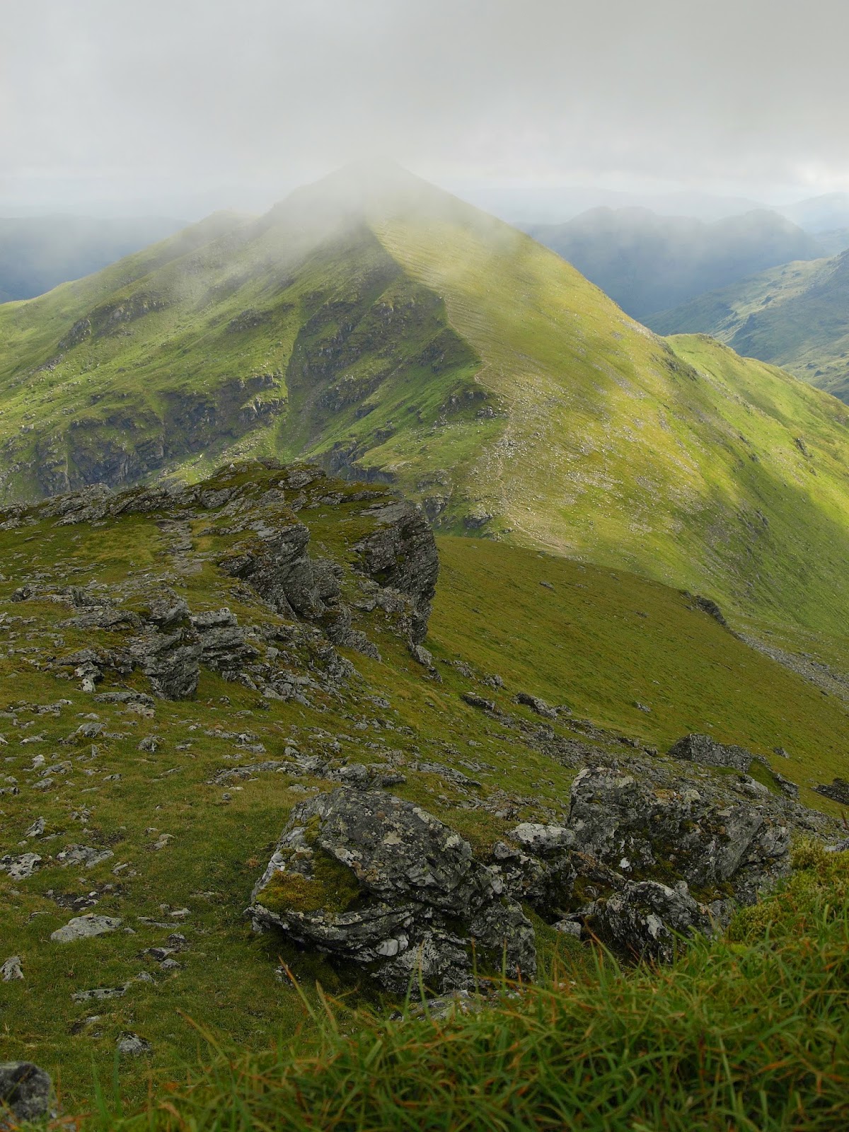
The first obstacle on the way bagged - on the top of Cárn Dearg Meadhonach- and the view looking back , down the ridge .


Ahead , the impressive cone of Cárn Mór Dearg.


The next stop , on the top of Cárn Mór Dearg. From here, we could clearly see the craggy walls in distance ,
where we were hoping to attack the summit . The clouds lingered over us , but fortunately it didn't rain .


The panorama of Cárn Mór Dearg Arete is breathtaking - the shoe horse-shaped  crest runs down and up Ben Nevis. What a great way to climb the summit , and what views around .


But reality was harsh - we were mowing painstakingly through the labyrinth of boulders , often jumping or balancing over the edge . It was a real test for my legs . Well , that was the cost of choosing the route with interesting scenery .


At the lowest point on Arete , the valley separating Cárn Mór Dearg and Ben Nevis opens up to all walkers.


We walked upwards again , but by the narrow path on the left side - many "co-walkers" continued over the very top of Arete . The Sun came out of the heavy clouds and we could enjoy the scenery - the mountains behind Glen Nevis looked splendid .


Finally , Arete was over , behind us . On the pass last stop before heading up onto a scree slope .


The track is clear at the beginning but soon disappears among crags, so advancing was slow. At some point I moved to my right side and I found tiny path along the edge of the cliff , close to the "North-East Buttress". Much easier as I didn't have to jump between boulders. Most hikers lost their path as well , so everybody was looking for most convenient way. The final climb is difficult through fields of stones and boulders scattered all over .


Finally , the plateau on the very top of Ben Nevis emerges , and the climb is over . Time to relax and take some photos . The summit with the ruins of the old meteo station is crowded - no wonder , on sunny Sunday like this one the mountain attracts crowds of hill walkers and even families with children.


Looking to the south-east from the top,  an impressive view - the mountain across Glen Nevis really glistens in the afternoon sunlight (Sgurr a' Mhaim) . It gave me an impression of looking at chalk cliffs , like sea-cliffs in Dover .
But it's not chalk , must be the same sort of weathered rocks  like here on Ben Nevis, shining when Sun comes out.


After taking our time on the summit , we didn't retraced our steps, as the walk is circular .We were descending by the standard track , towards the Lochan .


Having lowered to the crossroads , we left the main path ( tourist track ) and took the path towards the north tip of Lochan Meall an t-Suidhe . According to description on "Walking Highlands" , we should descent from that point northerly . The problem was , the path disappeared in the boggy moorland . We had seen walkers going down a bit earlier , but there was no path at all .
It puzzled as a lot, and after some unsuccessful search we decided to decent by no path . We could see the wood where we had started the walk in the morning , so the idea was to make a shortcut. As it would turn out later on , that was what we were supposed to do .


Finally, after fast and  difficult run down the grassy slopes , we reached rapids
of Allt a' Mhuilinn river. Crossing the fast-flowing stream was the last obstacle and now there was a simple walk through the forest to the car park. We could nearly  call it  a day .


Monday 27 October 2014

In St. Andrews


St. Andrews is mainly famous for its University ( the oldest in Scotland ) and being the birth place of  golf.. Golf's enthusiasts and players from all over the world come here to experience the reach tradition . For many visitors the focal point is the Old Cathedral (unfortunately in ruin since the Reformation time ). But for one visitor who came with me, the main reason was really unusual -having the second name St. Andrew . And coming to Scotland from the States , you are obliged to see this famous burgh .


St Rules tower - the only fully preserved part of big cathedral in St Andrews , which was the biggest in Scotland .


Strolling around the ruined temple , one can imagine how big and impressive this structure once was .


Next to Cathedral  another ruins - the castle perched on the cliff .


The path on the cliffs gives panoramic views across the beaches and sea .


Behind the castle to the north , a large sandy beach meets St Andrews Bay .
Nearby , large golf course overlooks the beach and waters of North Sea .


This Gull seemes to be not intimidated  by passers-by . 


The stroll around the Old Town is pleasant - nice and tidy streets . The medieval burgh was enclosed inside the fortified walls .
West Port , was one of the burgh's gates .


Near University , I found this plaque , commemorating the event . The famous American , one of the Fathers of United States was awarded by St. Andrews University when visiting Scotland .


 St. Andrews is a small town , so it dosn't require much walking . That leaves time for simply sitting by the cliffs and watching the sea or enjoying a cuppa in the old town . There are many reasons to go there one day again , anyway .

Saturday 30 August 2014

Ben More near Crianliarich


Ben More (1171) is the highest Munro's of the Trossachs Highlands , basically the highest south of Ben Lawers . Also ascending its top is consider as a very tough climb , so that makes this mountain very iconic . Although I am not a "Munros' bagger" , I have wanted to "bag" Ben More since  the time I had seen it first time. However as I hadn't hiked for long time , I didn't feel confident enough to start the climb from the north side on A85 , where the most popular route starts . Instead I choose the track going south, along east slopes and ascending on south-east ridge. That alternative seemed to be less strenuous , with more interesting terrain through the wood. I started from a small car park by the main road and then on the path along the burn .


On the higher ground above the forest I found the proper trail , vegetation-grown old landrover track. At some point the track crosses the wider road for forestry vehicles and the steep path winds up through the wood again .
On the photo ; looking back to the North and Glen Dochart .


Having emerged from the wood , I had to find a stile to cross a deer fence . The path going south is boggy and disappearing at places, I couldn't see in which direction should I go .


At last I saw the stile . I got on the other side and moved off  roughly westward, alongside the fence. The sun disappeared and for the next half an hour I was exposed to the rain . Luckily enough, when I got soaked and started cursing this damned weather , I found a big boulder with a  niche in it , large enough to shelter me from raindrops . I waited there 20 minutes till the rain stopped and then again on up the hill .


The sunshine was back for good and far away , as I looked eastward , I could see  Ben Lawers range .


The rugged ridge joining the summit was clear and close to me finally . I could assume , that I would be soon on the top . The fence was turning sharply right , and up towards the ridge . The path wasn't obvious again and I wasn't sure if the right decision would be to follow the fence . Eventually , I turned right along the fence , but  seeing no  clear path , I tried to get onto the ridge by shortcut , negotiating the steep , rocky slopes .


Traversing  the ridge I finally approached the main bulge of Ben More , the last ascent to the summit .I passed by a large patch of ice , a small " glacier " on the south side - I had read earlier that patches of snow could be seen on north face till early  summer . But that amount of hard snow in the beginning of August ?  I wondered if this was indeed the snow from the last winter . If so , this was really a miniature glacier .


Having started the final ascent on the grassy , steep incline ( that was hard work ), I suddenly heard a strange sound ; as if  frog was croaking. But frogs that high in Highlands ?
On closer inspection I saw a couple of birds moving amongst grass and stones - probably ptarmigans .


The higher the better vistas .
Stobinian , looking south from near the summit .


Finally , on the top - after 4,5 hrs walk just 15 minutes spent enjoying the panorama and having my lunch . Then back to the route , descending northward .


Despite being tired , I quickly ( I had to catch the return bus in Crianliarich ) rushed down . One hour later Ben More was behind me. I  started the last leg of my walk ,along A85 to Crianliarich.