NORTH HARRIS
Having spent two days in Lewis, I finished my Hebridean Oddysey by exploring a mountainous area of North Harris. The weather was still favourable ; warm and sunny, nearly windless what is not often in these parts. At the midday I arrived from Lewis at the foot of Clisham, the highest hill of Outer Hebrides (799). It had planned to climb its summit from the beginning, so not waiting for a better occasion I jumped onto the footpath. And it was worth getting on to the top, despite the fact the weather condition had deteriorated slightly up there. The sun disapeared somehow, but at least it didn't rain . The wievs were spectacular .
Views from Clisham
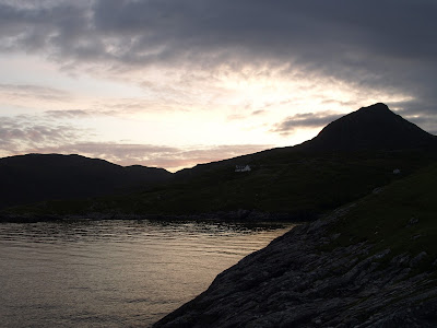
Tired after hiking, I rushed to Reinigeadal, a small vilage to the west of A859 connecting Tarbert and Stornoway. This is a cluster of cottages shattered by sea shore. Following a winding road I got there late afternoon and checked in a small hostel.Thanks to long hours of daylight (in July) I had a plenty of time to cook a hot meal in a hostel and to go for a stroll around a small cove nearby, before the darkness fell. It was really like being in the place at the end of the world. Looking west over the Sea I recognized a distinctive Skye's coastline - so far and so close from there.
Sunset over Reinigeadal
Scenery along the road to Huisinish
I left lovely Reinigeadal next morning and Headed to North Harris Eagle Observatory; on tuesdays mornings the North Harris Ranger is on hand to locate Golden Eagles on the skyline. There is about 20 pairs of these magnificent birds breeding on Harris. The observatory is located in Glen Meavig , in the mountains seven miles to the North-West of Tarbert. I had a luck that day to watch the resident pair of golden eagles, flying high over the mountain range. Glad to spot them, I drove on further west, to Huisinish .
The Huisinish beach
I had been told that Huisnish and surroundings would be great place for walk, and indeed the place turned out to be splendid, with one of the greatest beaches I have ever seen.The beach has a perfect, smooth sand and the colours of water change during a day. Few people and warm day - that was all I needed that day in Huisinish .
In Huisinish I took part in a guided walk across local Machairs with the same ranger I met in the Eagle Observatory. Machair is a gaelic name for coastal meadows, which are very fertile due to sand mixed with soil. Many species of plants thrive in that environment and ranger explained much aboutl flora and local agriculture too. The local fauna wasn't invting though; medges were bitting us mercilessly every moment we stopped.
Scarp, a small isle seen from Huisinish jetty
Road B887 , wiew toward Loch Leosavay
Having no spare time, I left Huisinish behind , driving to Tarbert. I take my time, as the coastal landscape was spectacular in the late afternoon sun rays.
The boat was a good pretext to stop and take a picture
On the way from Huisinish to Tarbert, at Amhuinnsuidhe, the road runs through an estate with a castle. Under an archway and through the garden drivers go past the castle - that's nice surprise.
Another surprising view, Cliasmol Primary School , almost in the middle of nowhere
The "Huisinish" road nearby the "Eagle Observatory"
The Sun was gone , shortly before I reached Tarbert. Tomorrow I will be leaving Tarbert and Western Isles, but the image of sunset over Harris will stay in my memory forever .
Map of Western Islands


No comments:
Post a Comment