Saturday, 30 August 2014

Ben More near Crianliarich


Ben More (1171) is the highest Munro's of the Trossachs Highlands , basically the highest south of Ben Lawers . Also ascending its top is consider as a very tough climb , so that makes this mountain very iconic . Although I am not a "Munros' bagger" , I have wanted to "bag" Ben More since  the time I had seen it first time. However as I hadn't hiked for long time , I didn't feel confident enough to start the climb from the north side on A85 , where the most popular route starts . Instead I choose the track going south, along east slopes and ascending on south-east ridge. That alternative seemed to be less strenuous , with more interesting terrain through the wood. I started from a small car park by the main road and then on the path along the burn .


On the higher ground above the forest I found the proper trail , vegetation-grown old landrover track. At some point the track crosses the wider road for forestry vehicles and the steep path winds up through the wood again .
On the photo ; looking back to the North and Glen Dochart .


Having emerged from the wood , I had to find a stile to cross a deer fence . The path going south is boggy and disappearing at places, I couldn't see in which direction should I go .


At last I saw the stile . I got on the other side and moved off  roughly westward, alongside the fence. The sun disappeared and for the next half an hour I was exposed to the rain . Luckily enough, when I got soaked and started cursing this damned weather , I found a big boulder with a  niche in it , large enough to shelter me from raindrops . I waited there 20 minutes till the rain stopped and then again on up the hill .


The sunshine was back for good and far away , as I looked eastward , I could see  Ben Lawers range .


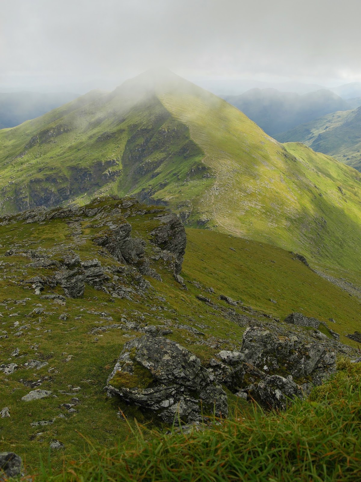
The rugged ridge joining the summit was clear and close to me finally . I could assume , that I would be soon on the top . The fence was turning sharply right , and up towards the ridge . The path wasn't obvious again and I wasn't sure if the right decision would be to follow the fence . Eventually , I turned right along the fence , but  seeing no  clear path , I tried to get onto the ridge by shortcut , negotiating the steep , rocky slopes .


Traversing  the ridge I finally approached the main bulge of Ben More , the last ascent to the summit .I passed by a large patch of ice , a small " glacier " on the south side - I had read earlier that patches of snow could be seen on north face till early  summer . But that amount of hard snow in the beginning of August ?  I wondered if this was indeed the snow from the last winter . If so , this was really a miniature glacier .


Having started the final ascent on the grassy , steep incline ( that was hard work ), I suddenly heard a strange sound ; as if  frog was croaking. But frogs that high in Highlands ?
On closer inspection I saw a couple of birds moving amongst grass and stones - probably ptarmigans .


The higher the better vistas .
Stobinian , looking south from near the summit .


Finally , on the top - after 4,5 hrs walk just 15 minutes spent enjoying the panorama and having my lunch . Then back to the route , descending northward .


Despite being tired , I quickly ( I had to catch the return bus in Crianliarich ) rushed down . One hour later Ben More was behind me. I  started the last leg of my walk ,along A85 to Crianliarich.


Saturday, 2 November 2013

New Lanark village

I have been long thinking about visiting New Lanark  and I finally went there , at the peak of Autumn . Not only to see historic mill village , but have a look at spectacular Falls of Clyde  .The power of the Falls has been long used for industrial purposes , to get the cotton  mill running and nowadays used by the  hydro-electric power station .


The cotton-spinning  company was founded in 1784 by entrepreneur from Glasgow , David Dale. There were built four mills along with large houses for over 2000 workers .The whole mill village has been declared as the World Heritage Site and visitors can find out about factory's past . At the time it was the biggest cotton-spinning business in Britain .


The series of cascades on River Clyde stretches among the woods far  from the historic mill . There is 5 km long walk upstream to the uppermost waterfall .


The first of upper waterfalls , Corra Linn .


 The golden foliage was a perfect frame for the  torrents mingling below.


Bonnigton Linn , the uppermost waterfall on River Clyde .


The final cascades seen from the other side of River Clyde (after crossing the bridge behind Bonnigton Linn ) looks like a little Niagara Falls . I thought there that if I had lost my footing and slipped down the steep bank, I wouldn't have probably survived the slid on the rocky steps  .


Back at the historic village , I admired the waterwheel , once used to drive factory . The wheel wasn't propelled directly by the river's stream , but by waters of canal diverted from the River Clyde .


New Lanark village is famous not only as a fine example of historic industrial mill , this is a place where Robert Owen started developing his ideology .Owen is wide known as a first socialist philosopher , and in New Lanark he developed his vision of a new society. Having bought the mill in 1799 from his father-in-law , David Dale , he ordered to build a couple of buildings to improve lives of his workers . Owen created public paths for leisure , schools for infants and adults , library.  He established the rule that children under the age of 10 weren't allowed to work. It was usual practise at the time that kids started working at the age of 5 .


                                                             The school house in New Lanark

                                         Robert Owen's house (in the centre of the picture above) .


New Lanark is worth visiting  not only for it's UNESCO status , but because it is really an awesome place .

Saturday, 28 September 2013

Schiehallion - Fairy hill of Caledonians

Schiehallion is one of the most iconic Munro's ; surely its symmetrical shape seen from the distance is well recognisable.That feature has attracted people long ago - humans presence on Schiehallion is dated back since 3000 years ago , possibly as a place of ritual practises. The mountain was also the place of scientific experiment in 18th Century by astronomer Nevil Maskelyne , who measured  'the weight of the world' by setting up observatories on either sides of Schiehallion .


On my way to Schiehallion I stopped at the famous viewpoint nearby Pitlochry , Queen's View . Widely believed to be named after the visit of Queen Victoria in 1866 , but probably, as the inscription says , the spot memorise Queen Isabella , the wife of Robert the Bruce .

View from the viewpoint over Loch Tummel , with Schiehallion seen further beyond the Loch .


After a nice drive through Tay Forest Park , I approached the beginning of the trail  to Schiehallion's summit , which starts from the car park at Braes of Foss . The mountain from that point didn't look so impressive as earlier did over Loch Tummel , loosing somehow the symmetrical shapes of a big cone .


The path leading on the main ridge is clear and well maintained - the John Muir Trust managing the eastern slopes of Schiehallion did well job . There is a few walking paths in Highlands so well maintained . Beside , the very top of Schiehallion is well visible , so it's nearly impossible to get lost .


 From the first cairn on the main ridge , walking is easier as the incline is less steep, although more shattered pebbles appeared.


The final ascent is rugged ; looks like a devil's job - what's more the path disappears and I had to wade in the stony field , stretching wide and up to the very top . Later on I found the path on the left edge of the ridge , where walking was easier on patches of grass.


On the top the views were splendid , the sun shinning and nearly no wind - so that was really nice to sit for a lunch, looking down to Loch Rannoch . More walkers came and sat around the top , enjoying the bright day after the climb .


Later in the afternoon , I was looking over Loch Rannoch toward Schiehallion , so symmetrical shape . The spot where I took the picture is called  locally  ' The shore of the hanging trees ' - in the years following the battle of Culloden in 1746 many clansmen or common cattle thieves were hanged on this shore, as part of campaign to subdue Highlanders by the British Crown . A bit sad story - but anyway it was a good day .

Friday, 16 August 2013

Ben Vane

Ben Vane  is a Corbett Hill, which was the next on my list of hills in the Trossachs area . This is a hill which could be quite easily climbed from the south side off Balquhidder and offers good views around southern Highlands . In Balquhidder  you may stop at a local parish graveyard , famous for the rest-place of legendary  Rob Roy .


Having left A84 at Kingshouse I drove westwards and stopped shortly in Balquhidder by the parish church . Although the church's graveyard is believed to has been a burial place of Rob Roy , the detailed information says that it's not quite sure. But certainly Balquhidder is the place where famous ( or infamous ) chieftain spent his last years and died in a duel .


Shortly after the church I turned left and looking right to the west I could see the shores of Loch Voil . Soon after the bridge I choose the narrow road , going south through the wood to Ballimore.


Before I reached the farm in Ballimore,
I was able to asses the distance to walk - Ben Vane emerged behind the first line of hills .


I left the car by the bridge in Ballimore, and as I crossed the stream , I turned immediately to the right , stepping onto the path  marked as the ' footpath to Brig o' Turk' .


The footpath crossed muddy patches at first , and after getting over a metal gate I walked westwards along the same stream I had crossed by the farm. I was on the path described on 'walkhighlands' website , and according to the instruction I should follow till the end of north-west shoulder of Ben Vane . At that point I should leave the path and climb the grassy slope on my left . What I did .


On the ascent to the main ridge , I v'e taken the picture looking back to north-west and tops of Ben More and Stobinian towering in the background .


Zigzagging and partly traversing the slopes using sometimes tiny paths , I got to the main ridge.
Down to the right , Glen Finglas Reservoir is clearly visible.                           


On the final ascent to the top , the impressive view of Ben Ledi


Finally , on the summit of Ben Vane (818 m), marked with a small cairn . I put my own smal piece of stone on it.


Not much to do on the top, although the views were nice. I looked down on the grassy ridge , rolling mildly south to Ballimore - the return walk seemed to be pleasant .


Nice path ( at places over small bogs )
leads all the way down to Ballimore


The return way is easy and simple and I think it wasn't longer than 1.5 hrs of walking down to the farm .


Monday, 5 August 2013

Bagging Stuc A' Chroin

I had had an unfinished business , after having climbed Ben Vorlich a year ago without taking on Stuc a' Chroin . These two Munro's are very close to each other , and both might be done by walking circular route from south shore of Loch Earn . I decided to start from Loch Lubnaig in Trossachs , a couple of miles north-west off Callander .


I started early morning by the farm and lodge in Ardchullarie More , on A84 road . I followed the path left off the buildings .


Soon I joined a broad , steep track in the forest which I followed upwards.


After steep ascent , I left the wood behind my back . And looking back , the view on Trossachs across Loch Lubnaig with Ben Ledi in the background .


Enjoying sunny and bright morning , I shortly reached a signpost , which redirected me to Beinn Each - a Corbett Hill (813m) which was a first obstacle on the way to Stuc a' Chroin .
A tiny path runs to the left (eastward) and winds up amidst brackens, densely covering the slopes .


 I was patiently going up when I spotted a pair of wild goats . I was really in awe , looking for the first time at these animals .


After two-hours walk from the starting point, I reached the top of Beinn Each ,
with the main objective of the day still to be climbed .

View from the top of Beinn Each to the North-West .


From the top the path goes down to the left and zigzags on to the rocky ridge, which stretches out of Beinn Each to Stuc A' Chroin .


The path on the ridge is difficult and sometimes hard to read , but in general runs along the rusted fence posts , what is helpful .


At the end of the ridge I lowered to a boggy pass ,and  the path turned right to the east and finally I started ascending the Munro . Again the metal posts were along the path , showing the way to the top .


Close to the summit , I came across a herd of sheep; much higher than wild goats .

Down at the foothills Lochan a' Chroin.


After 3,5 hrs walk , I got at last onto the top plateau and followed to the north tip , where the path from the south-east (to Callander ) joins .

Unfortunately , the thick coat of  mist covered the mountains . Not only the mist , a drizzle came with the wind .Not being sure of finding the alternative return route in these conditions ( which goes north and turns west to Glen Ample), I took back to the same path I had come to.


Descending the Stuc a' Chroin was a bit a tricky , due to wet ground after droppings .On the lower slopes the air cleared out and Beinn Each was fully displayed .


Having descended the Munro's , I did not follow the path to Beinn Each as on my way onward . Instead , I choose a hardly seen path ( used by deers perhaps or sheep ) , which goes off to the west from the bog  where the rocky ridge starts . I simply followed along a small burn to Glen Ample , through the heater and grass .


After getting down to the plantation , I found the path running along the fence . The last difficult passage ( at some point the path disappears)and I got to the bottom of Glen Ample .From there  the wide track led me back south to Loch Lubnaig .